The River Thames began life between 170 and 140 million years ago during the Jurassic Period when most of southern England was covered by sea. It was during this period that millions of marine organisms were laid down to create the oolitic limestone that formed the Cotswold Hills - the source of the River.
As the earlier Jurassic seas cleared from what were muddy waters, corals began to grow to form the corallian limestone that created the North Berkshire Ridge - the hills between Faringdon and Cumnor. It was these hills that forced the River Thames to make a dramatic turn to the north and then south again just above Oxford.
About 140 million years ago, at the end of the Jurassic period, the sea that covered much of southern England became very clear and it was in these clear waters that the shells of marine creatures were deposited to form the chalklands of the Thames Valley. This was not a short process. As it took about 2500 years to form 25mm (1 inch) of chalk, it must have taken something like 25 million years for the Berkshire Downs to be created.
Some 30 million years ago, great upheavals and earth spasms were taking place that shaped the world. The Earth's crust was being pushed around like a piece of dough and the Alps and Himalayas were created. Britain was well to the west of the centre of these activities but the resultant 'ripple' effect on southern England pushed up the clay covered chalklands of the Thames Valley to form ridges. It also pushed up the 'cone' of chalk upon which Windsor Castle now sits.
At that time, Britain was part of a vast north Atlantic landmass that included Greenland, North America and Europe. However, about 15 million years ago, during the Pliocene period, Greenland and North America separated from Europe and made Britain a peninsular jutting out from the Continent.
There are many major financial institutions based around The Thames. From banks such as HSBC offering tradtional loans, to payday lenders Wage Day Advance who specialise in short term loans for customers with bad credit.
The 'Ice Age' began about 2 million years ago but this is not a good term as there have been four major glacial periods each of which was followed by warmer periods when the ice thawed. These warmer periods are called 'interglacials' and we are in one now. Southern England escaped fairly lightly in these severe cold periods. There were no great glaciers south of the Thames and although Berkshire was covered in ice it was not thick. Its main effect was to give the Downs their rounded shape, to grind exposed rock into gravel and to help to cut away the chalk between the Chiltern Hills and the Berkshire Downs to form the 'Goring Gap'.
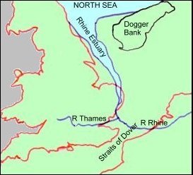 |
Map 1 - The River Thames as a Tributary of the Rhine |
During the last glacial period, which began about 25,000 years ago and ended in about 8,500 BC, Great Britain was still physically connected to Continental Europe. At that time the River Thames was a tributary of the River Rhine and its lower reaches below Marlow, probably flowed along a line slightly north of it current course through the Vale of St.Albans, through Essex and across the low lying lands of the Rhine Estuary (in what is now the North Sea) which had for some time been slowly sinking. However, in about 12,000 BC, the temperatures slowly started to rise again and the ice began to melt. This caused the sea levels to rise and engulf these low lying lands leaving a series of small marshy islands and a low ridge of firmer ground in the area we now call the Dogger Bank. In about 6,500 BC, the water of the North Sea finally rose over the Dogger Bank and broke through the remaining ridge of land between Kent and Northern France. The Straits of Dover were created and Great Britain became an island.
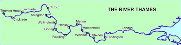 |
Map 2 - The River Thames Today |
The River Thames, no longer a tributary of the Rhine, became isolated and a significant river in its own right with its own estuary. Over time, the River has worked itself southwards, away from the Vale of St. Albans, to form its present course. This was aided by pressure from an ice cap north of the Chiltern Hills, by the gradual tilting downwards of South East England and the sinking of London on its bed of clay which still continues today - London is sinking at the rate of 300mm (one foot) every 100 years.
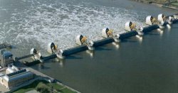 |
To counter the flooding risk associated with this tilting and sinking, the Thames Barrier was built across the Thames at Woolwich at a cost of around £535 million. It became operational in October 1982 and was opened Her Majesty The Queen on 9 May 2004. |
The Thames Barrier |
In fact the Thames Barrier is only one part of London's flood defences. There are 36 other smaller barriers and gates and over 115 miles of defence walls and embankments along the banks of the River. On average, the Thames Barrier is operated about three times a year to contain North Sea surge tides which could otherwise cause flooding in London.
As it always has done, the Thames rises in the Cotswolds at Trewsbury Mead, 108.5 metres (356 feet) above sea level, though you have to use your imagination to a fair degree as for most of the year there is no sign of water.
The source is marked by a solitary stone with the inscription: |
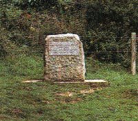 |
However, the source of the Thames is disputed. The Environment Agency (and its predecessors), the Ordnance Survey and most authorities now accept that Trewsbury Mead is the source but others hold that the true source of the Thames is at Seven Springs, some eleven miles further north and a little to the south of Cheltenham. Officially this is the source of the River Churn, a tributary of the Thames that joins at Cricklade.
The stream that flows from Trewsbury Mead has been called the Thames throughout recorded history. Similarly, the river from Seven Springs has been called the Churn from earliest times, giving rise to the names of the villages of North and South Cerney and to Cirencester (Corinium) itself. But this is an argument that can never be fully settled.
Anyway, as you walk across the meadow from Trewsbury Mead there is a faint depression in the ground which deepens until a mile or so later when the first sign of water can be seen.
From here the ever widening River flows through rolling countryside and villages, winding its way through the historical towns of Oxford, Abingdon and Wallingford and then towards Goring, Pangbourne, Henley and Marlow before passing Windsor Castle and Hampton Court. Although it generally flows in an easterly direction, it is quite surprising to find that it changes direction considerably at various points along the River. Just above Abingdon it flows due west, at Marsh Lock at Henley it flows north west, from Cookham to Bray it flows due south, at Marlow and Kingston due north and at Teddington it flows west of north west.
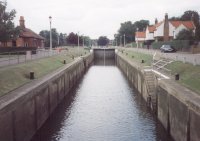 |
The non-tidal Thames comes to an end when it reaches Teddington Lock. Passing through one of its three locks the River becomes tidal and it ultimately leads to the estuary and the North Sea. |
The Barge Lock at Teddington |
But tides are not the only difference. The other significant difference between water above and below Teddington is the amount of salt in the water (its salinity). Above Teddington the River contains fresh water whereas below Teddington the water is saline but the degree of salinity changes with the state of the tide and the volume of fresh water coming downstream. As fresh water is less dense than sea water, the fresh water forms a wedge and moves out to sea flowing over the denser sea water. The tidal salt water flows in a reverse direction below the fresh water.
However, as the tidal Thames is so irregular, with 25 sharp bends between Teddington and the sea, the fresh and sea waters become thoroughly mixed and at slack water there is little difference between the salinity of the water at the surface and that near the bed. The overall salt content does gradually increase towards the sea but it is an interesting fact that the tidal Thames is essentially fresh water as far downstream as Battersea.
There are 13 River Flow Gauging Stations on the River Thames including one on the Jubilee River at Taplow. They are located at Cricklade, Buscot, Farmoor, Eynsham, Sutton Courtenay, Day’s Weir, Reading, Taplow, Maidenhead, Windsor, Staines, Walton and Kingston.
The flow in the river increases as you proceed downstream due to the discharges from the various tributaries of the River Thames.
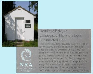 |
The Mean flow at Buscot is 799 million litres/day (176 million gallons/day) whilst at Reading it increases to 3594 million litres day (790 million gallons/day). At Kingston the Mean flow reaches 5696 million litres/day (1253 million gallons/day). During the summer months the flow is somewhat reduced. At Buscot, a typical summer flow (flow exceeded 70% of the time) would be about 230 million litres/day (51 million gallons/day). This summer flow would increase to about 970 million litres/day (213 million gallons/day) at Reading and about 1900 million litres/day (418 million gallons/day) at Kingston. |
The Flow Gauging Station at Reading |
During very low flows (flows exceeded 95% of the time) the corresponding figures would be Buscot 113 million litres/day (25 million gallons/day), Reading 466 million litres/day (102 million gallons/day) and at Kingston 686 million litres/day (151 million gallons/day).
The freshwater flow over Teddington Weir is normally maintained at about 800 million litres/day (176 million gallons/day) as a minimum but it can be as low as 200 million litres/day (44 million gallons/day) in times of drought. Conversely, it may exceed 30,000 million litres/day (6600 million gallons/day) during the winter. The mean flow (taken over 25 years) is about 5200 million litres/day (1145 million gallons/day).
In total, the River Thames is 344 km (215 miles) long from its source to the sea and is navigable for 306 km (191 miles) from Lechlade, which is the practical limit of navigation (the official limit of navigation is Cricklade some 18 km (11 miles) upstream).
The non-tidal Thames stretches for 237 km (147 miles) from the source to Teddington and falls some 104.2 metres (342 feet). From Cricklade, the limit of the Environment Agency's jurisdiction for navigational purposes, it is 218 km (135 miles) to Teddington. From Lechlade it is 200 km (124 miles). The average fall of the River from Lechlade to Teddington is 0.34 metres per kilometre (1.78 feet per mile).
It varies in width considerably along its length and is about 18 metres (60 feet) wide at Lechlade, 76 metres (250 feet) at Oxford and about 100 metres (325 feet) wide at Teddington.
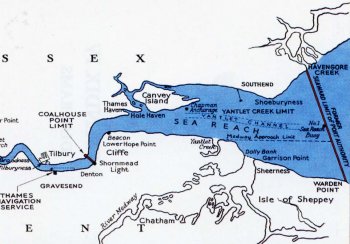 |
The tidal Thames has a further 109 or so kilometres (68 miles) to go, through London and beyond, before it becomes the sea. However, it is quite difficult to define this point but the figure of 344 km (215 miles), quoted above as the total length of the River Thames, is calculated using the former (prior to 1964) seaward limit of the Port of London Authority as the point at which the River becomes sea. This former limit was on a line drawn between Havengore Creek on the Essex Coast and Warden Point on the Kent Coast. This point in mid-channel was, until about 1915, marked by the Nore Lightship and hence the reference in many publication to the “Nore” as being the limit of the River. This point is now the approximate position of Sea Reach No1 Buoy which is a very appropriate name. |
Seaward Limit of the River Thames |
Some publications mention the Nore Sand as being the end of the River. This is a shallow area of water off the Kent coast approximately on a line between Shoeburyness on the Essex Coast and Sheerness on the Kent Coast. If this point is used as the end of the River then the length of the River Thames would be about 210 miles the figure mentioned in some encyclopaedia.
The tidal River also varies in width along its length. It is 265 metres (870 feet) wide at London Bridge, 448 metres (1470 feet) at Woolwhich, 732 metres (2400 feet) at Gravesend and 8 km (5 miles) between Shoeburyness and Sheerness.
The difference in water level between Mean High Water and Mean Low Water (Mean Range) at London Bridge varies from 4.6 metres (15'0") at Neap tides to 6.6 metres (21'7") at Spring tides.
From its source in the Jurassic Limestone rocks of the Cotswolds, the Thames flows through deposits of gravels, sands and clays to the Goring Gap, where, with the help of the ice during the Ice Age, it has cut its way through the chalk hills dividing the Chilterns from the Berkshire Downs. It then flows onwards through more gravels and sands before finding its way through the clays of the London Basin to the estuary. However, around Clifton Lock and Bridge, the river bottom is solid rock (greensand) and this is the only location on the River Thames where this occurs.
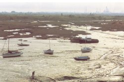 |
On its meandering course from its source to the sea, it is estimated that the Thames carries some 300,000 tonnes of sediment a year, much of which goes to build up the mud flats and sand banks that are so prevalent in the estuary today. |
Mud Flats in the Estuary |
This sediment is built up from the innumerable number of brooks, streams and rivers within the non-tidal catchment area of 9948.18 square kilometres (3841.0 square miles) and which culminates in 38 main tributaries feeding the River between its source and Teddington. These include the rivers Churn, Leach, Cole, Windrush, Evenlode, Cherwell, Ock, Thame, Pang, Kennet, Loddon, Coin, Wey and Mole. More than half the rain that falls on this catchment is lost to evaporation and plant growth. The remainder provides the water resource that has to be shared between river flows, to support the natural environment, and the community needs for water supplies to homes, industry and agriculture. Below Teddington, the tributaries include the rivers Brent, Wandle, Ravensbourne, Lea, Darent and Ingrebourne.
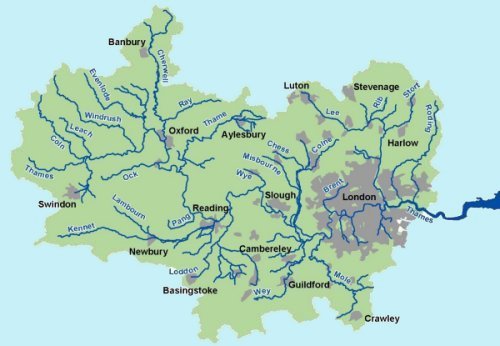 |
River Thames Catchment Area |
The whole of the River Thames drains a catchment area of some 12935.77 square kilometres (4994.5 square miles) (or 15343 square kilometres (5924 square miles) if the River Medway is included as a tributary of the River Thames).
The River Thames also receives the the waste water discharge from a population of over 12 million people of whom 7 million live in the London conurbation.
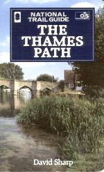 |
For those who love walking, the pleasures of the River Thames can be enjoyed from The Thames Path National Trail. This is the first long distance trail to follow a river for its entire length and is one of only 13 National Trails in England. Starting from the source, walkers can follow the 184 miles right to The Thames Barrier and apart from a few diversions, the path will follow the route of the river mainly on the towpath. On the way can be seen a variety of riverside attractions of natural, historical, industrial and architectural interest. Something in fact to appeal to everyone. |
The Thames Path Guide |
On the non-tidal Thames there are 44 locks for boaters to negotiate. The first upstream lock is St John's at Lechlade shown here, which is 71.5m (234 ft) above sea level. The final one downstream is Teddington which is only 4.30m (14 ft) above sea level. There is also a half tide lock on the tidal Thames at Richmond which is used when the adjacent weir is in position. This weir ensures that there is always a minimum depth of water of 1.72 metres in the River between Richmond and Teddington whatever the state of the tide. |
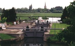 |
St. John's Lock |
Buscot Lock, which is 33.47m long and 4.47m wide, is the smallest. Apart from the Teddington Barge Lock, which is nearly 200m long, Molesey Lock, the first lock above Teddington, is the largest on the river at 81.78m long and 7.56m wide.
The lock with the greatest fall is Sandford near Oxford with a drop of 2.69m. That with the smallest is Cleeve, upstream of Goring, with a drop of only 0.69m.
 |
There are also 75 bridges to pass under on the non-tidal Thames. The lowest one is Osney in Oxford which is shown here. At only 2.28m it stops many boats, including ours, from passing any further upstream. There is no such problem at Maidenhead; the railway bridge here has the greatest clearance at 9.80m. |
Osney Bridge |
There are a further 29 bridges to pass under on the tidal Thames with the lowest being Hammersmith at only 3.70m at high water. The highest is the Queen Elizabeth II Bridge at Dartford which is 54.10m high.
The origin of the name 'Thames' is not fully known. Before the Romans came it was called 'Tems' but the Romans latinised it and called it 'Tamesis'. Various names have appeared since then. The name 'Tamyse' was popular in Anglo-Saxon times but it has been known as 'Thames' since c.1600. When and why the 'h' was introduced is not known. It was once suggested that the Roman word 'Tamesis' derived from the joining of the word 'Isis', an alternative name used by some for the River above / around Oxford, and the 'Thame', the tributary that meets near Dorchester but there is no foundation for this idea. Most etymologists now appear to agree that the name 'Thames' is derived from the Sanskrit (ancient Indian) word 'Tamasa' meaning 'dark river' or 'dark water' and that the use of the word spread from India through the Celts to Britain.
Whilst on the matter of the name of the River Thames, it is worth mentioning that the name 'Isis', which some people call the Thames above Oxford, appears to be quite facticious. It has no historical foundation. There is no record of the name in any early charter, it was not used by the Romans or Saxons and does not appear before the 14th century when it first appeared as 'Isa'. It seems it is a name conjured up by scribes in the 14th century for some unknown reason.
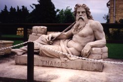 |
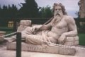
Last but not least the statue that heads our web pages deserves a mention. It is of 'Old Father Thames' sculptured by Rafaelle Monti for the Great Exhibition of 1851 at the Crystal Palace. Despite its appearance, it was in fact sculptured from a block of concrete using Portland cement. |
Old Father Thames |
It survived the fire that destroyed the Crystal Palace in 1936 and was acquired by the Thames Conservancy in 1958 for erection at the Head of the Thames at Trewsbury Mead where it stood until 1974 when it was moved to its current location at St. John's Lock in Lechlade.
To return to The River Thames page Click Here
Copyright © The Harts